
A previous post, opens a new window in the library's Celebrating the Tricentennial, opens a new window series discussed the founding of New Orleans in 1718, but equally interesting is the establishment of the city's grid. Shortly after the city's founding John Law's Company of the West, opens a new window faced financial disaster. The new company bureaucracy began trying to dig itself out of its financial disaster, and meanwhile, Bienville, opens a new window was busy directing new settlers to New Orleans by offering land and slaves.
However, the fate of New Orleans lay primarily with the royal engineers—the people who actually planned and built colonial towns. Until they arrived, everything was only temporary. Because of the flooding in New Orleans, the new directors of the Company of the West were seriously considering relocating the capitol to Biloxi, but wanted to make sure the expense was absolutely necessary. Royal engineers arrived in Biloxi in late 1720, and the chief engineer Louis-Pierre Le Blond de La Tour, directed second engineer Adrien de Pauger to travel to New Orleans in March 1721.
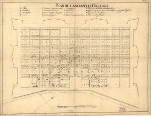
When Pauger arrived, he was surprised to see that inhabitants had built dwellings wherever they pleased, streets were askew, and the city seemed to be fighting a losing battle against the encroaching forest. However, Pauger saw something of promise in the city and began work immediately to clear additional land. He also started laying out the famous French Quarter grid. His plan included a 6-block by 11-block grid and centered around a church (present-day St. Louis Cathedral) on an open square (present-day Jackson Square) fronting the Mississippi River. Pauger named the streets on the grid in a political nod to those in power: Bourbon, Royal, Dauphine, Bienville, Conti, and Orleans.
He sent his map to Biloxi in mid-April 1721. It was adopted quickly by the Company of the West directors, and on December 23, 1721, the company issued instruction that its headquarters and colonial capital be relocated to New Orleans. When the orders arrived, La Tour took charge of the site as though he was the architect of the grid.
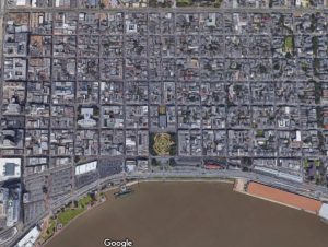
What we now know as the French Quarter had been born. Today, Pauger's original street design is still in place. De Pauger planned the streets out from the river to Rampart and from Canal to Esplanade, but by 1728, the city was only occupied from Bienville to Arsenal (now Ursulines), the river to Dauphine.
Interested in learning more about the early history of New Orleans? Check out one of the titles below that were consulted in the writing of this blog.

Add a comment to: Celebrating the Tricentennial: French Quarter Grid